Greetings BRCWRT Members and Friends - I trust you and your family and friends are doing well and remain safe and healthy. This edition of Preservation Corner provides information and updates on several preservation activities and initiatives of specific interest to BRCWRT, information on a recently emergent threat to Manassas National Battlefield Park and information on the recently released Road to Freedom Toru Guide App.
Last year Friends of Cedar Mountain Battlefield (FCMB) was one of four organizations in Virginia to be awarded an American Battlefield Protection Program grant through the National Park Service. FCMB applied for the grant in order to seek funding to undertake field and documentary research for a Rapidan Front Landscape Study focused on Raccoon Ford, Morton's Ford and Somerville Ford battlefields, as well as the 1863-1864 Union Army Winter Encampment in Culpeper County.
Virginia witnessed more Civil War activity than any other state, and Culpeper County is one of ten Virginia counties where the action was most heavily concentrated. The Rapidan fords were strategically important during the war and merit this intensive study. The 1863-1864 Winter Encampment comprising more than 100,000 Union soldiers covered almost half the county.
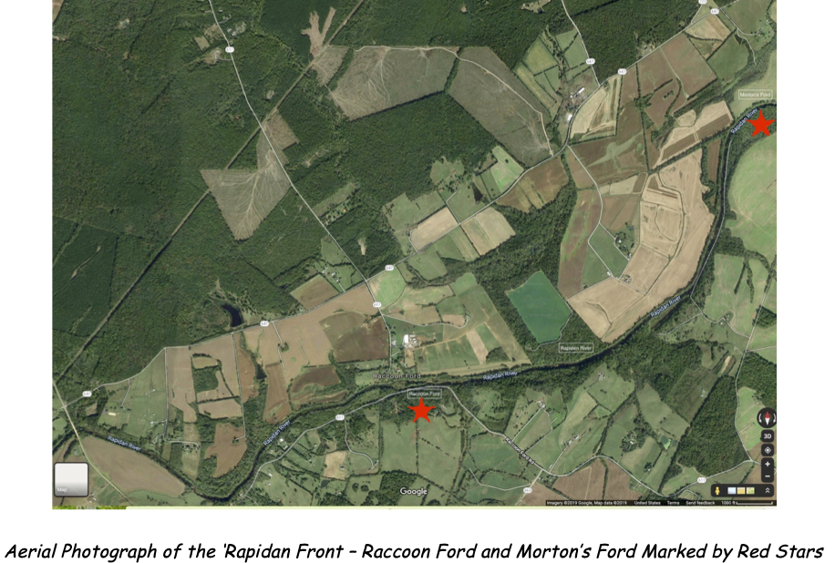
The FCMB grant research team has been hard at work studying primary and secondary sources including the Official Records, historic maps, photographs and drawings; soldiers' memoirs; military unit histories; and scholarly books and articles. Their ongoing research will open additional resources for heritage tourism as well as economic development opportunities for small businesses such as campsites, water recreation and guided tours.
Culpeper's Civil War landscape has an overall high level of integrity that contributes to the integrated study of the battlefields, camps and troop movements. However, this integrity is threatened by utility scale solar energy project proposals that continue to target Culpeper County's rural land and the grant area of study in particular.
Questions or information on the grant may be addressed to Friends of Cedar Mountain Battlefield at info@friendsofcedarmountain.orgRoute 28 Bypass Project
The Northern
Virginia Transportation
Authority (NVTA)’s Route 28
Transportation Study and
Project is
focused on infrastructure
projects to improve travel
times and network
reliability on Route 28
through
Prince William County, the
City of Manassas and the
City of Manassas Park.
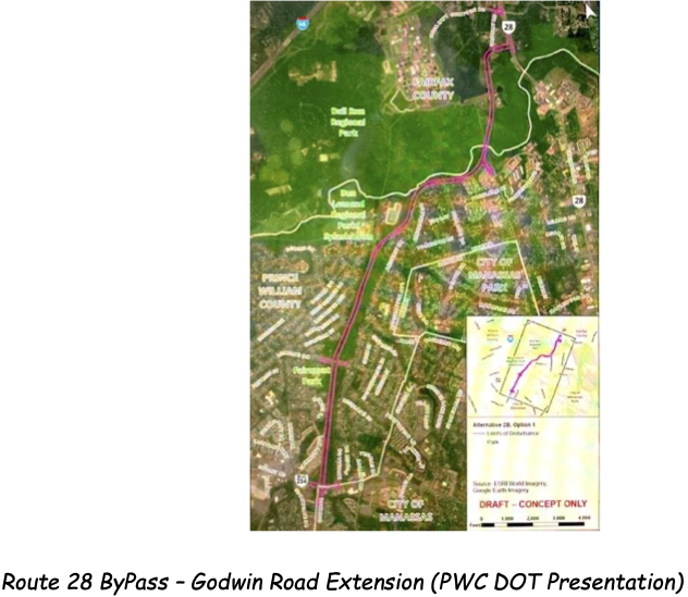
Based on results of NVTA’s Transportation Study and a Prince William Staff recommendation, in 2020 the Prince William Board of County Supervisors adopted Alternative 2B (Godwin Drive Extension) as the route for the Route 28 ByPass. Since that decision the PWC Department of Transportation (DOT) has conducted two virtual, interactive information sessions for county residents and other interested parties, and on March 23, 2021 initiated a Transportation Tuesday forum that is scheduled to be conducted 12:00 – 12:30 PM on the last Tuesday of each month. Each Transportation Tuesday session will focus on a specific topic/issue associated with the Route 28 ByPass project. The forum’s initial session on March 23, 2021 focused on Environmental Impact & Concerns. The forum sessions are designed to answer specific questions submitted by residents or concerned individuals, and questions may be submitted prior to each session. Each session will be recorded and is accessible at www.route28bypass.com. Information on registration and questions regarding this forum can be obtained via email to info@route28bypass.com
BRCWRT will continue to monitor this project and, in collaboration with NOVA Parks and Manassas National Battlefield Park (MNBP), will engage with PWC DOT when an historical and/or cultural site(s) is (are) potentially threatened by project engineering designs and/or project activities or actions.
Prince William County (PWC) Digital Gateway Proposal (new)
Recently a group of PWC “Rural Crescent” landowners revealed plans for an 800-acre data center development along Pageland Lane and adjacent to Manassas National Battlefield Park and the Brawner Farm. Referred to as the PWC Digital Gateway, the proposal strings together 30 parcels of agricultural land belonging to 15 property owners and envisioned to be developed by a single data center developer.
The proposal envisions constructing a large concentration of data centers on land that is not within PWC’s designated Data Center Overlay District, and is well within PWC’s designated Rural Crescent. Based on this location, adopting and implementing the proposal will require PWC’s Board of County Supervisors to approve a change (Amendment) to the Comprehensive Plan, approve rezoning requests for industrial use of the land (which is within PWC’s Rural Crescent) and approve Special Use Permits for the data centers.
In addition to these significant county land use issues, the proposal is problematic from historical and electric power perspectives. The 30 land parcels identified in the proposal lie within areas identified by the Congressionally-established American Battlefield Protection Program (ABPP) as Battlefield Core Area and Battlefield Study Area for the two Civil War Battles of Manassas (Bull Run). (Manassas National Battlefield Park’s current boundaries do not encompass all of the designated Battlefield Core Area or Study Area.) Additionally not all of the 30 parcels identified in the proposal are contiguous – the parcels are “split” by 167 acres of land owned by the American Battlefield Trust (ABT) and that is within the Manassas Battlefield Core Area. The proposal parcels are grouped into two clusters, a north cluster and a south cluster along the Pageland Lane corridor, separated by the 167-acre section of
Battlefield Core Area owned by ABT. Land within the Battlefield Core Area is eligible to be considered for incorporation into Manassas National Battlefield Park (MNBP). Realigning MNBP boundaries to incorporate Battlefield Core Area land requires Congressional legislation, but imagine the visual impact and visitor experience impact resulting from a portion of MNBP’s historic battlefield being surrounded by large and noisy data centers.
From an electric power perspective, the 30 land parcels are in proximity to an existing Dominion Energy transmission line along Pageland Lane south of U.S. Route 29 (Lee Highway); however, that transmission line is “at capacity” meaning that any data centers built in the Pageland Lane corridor north of U.S. Route 29 will require new power stations and/or transmission lines to provide the power necessary to operate the data center(s). Again, the visual and visitor experience impact on MNBP, and particularly on Brawner Farm, would be significant.
Readers of this column, and particularly readers who are Prince William County residents, are strongly encouraged to contact the PW Board of County Supervisors and/or their respective PWC District Supervisor and let the supervisor(s) know of their concerns with the PWC Digital Gateway Proposal, the negative impacts that would result from approving any portion of the proposal and their non-support of the proposal.
PWC Board
of County Supervisors:
Chair (At Large): Ann B.
Wheeler – chair@pwcgov.org;
703-792-4640
Neabsco District
Supervisor: Victor S.
Angry – vsangry@pwcgov.org;
703-792-4667
Brentsville District
Supervisor: Jeanine M.
Lawson - jlawson@pwcgov.org;
703-792-6190
Coles District
Supervisor: Yesli Vega –
yvega@pwcgov.org;
703-792-4620
Gainesville District
Supervisor: Pete K.
Candland – gainesville@pwcgov.org;
703-792-6195
Occoquan District
Supervisor: Kenny A.
Boddye – kboddye@pwcgov.org;
703-792-4643
Potomac District
Supervisor: Andrea O.
Bailey, Vice Chair – abailey@pwcgov.org;
703-792-4563
Woodbridge District
Supervisor: Margaret
Angela Franklin, Chair
Pro-Tem – mfranklin@pwcgov.org;
703-792-4646
The Road
to Freedom Tour Guide
highlights Virginia’s
Civil War-era African
American experience,
encouraging visitors and
Virginians alike to
uncover these
little-known stories of
strife, growth,
community, and more. It
unleashes the power of
both perspective and
place and introduces
historical
figures that have been
given little voice until
now. This application
allows you to interact
with these
stories in various ways.
You can explore the Road
to Freedom sites at
large, and investigate
the state’s
history through tour
collections for
particular Virginia
cities and themes, and
read the illuminating
narratives of key events
and locations.
Developed through a partnership between the American Battlefield Trust (ABT) and Civil War Trails
(CWT), this application came about as a supplemental resource to the printed Road to Freedom map and
brochure, available in visitor centers across the Commonwealth of Virginia. This free app is available for
iOS and Android devices and is also available online as a web app. Available in the App Store and on Google Play.
Thank you for your continued interest in, and support of, BRCWRT’s historic preservation actions and activities. Stay strong, stay safe and stay healthy in 2021!
Blake Myers, BRCWRT Preservation Chair