www.route28bypass.com.
The Northern
Virginia Transportation Authority (NVTA)’s
Route 28 Transportation Study and Project
is focused on infrastructure projects that
will improve travel times and network
reliability on Route 28 through Prince
William County, the City of Manassas and
the City of Manassas Park.
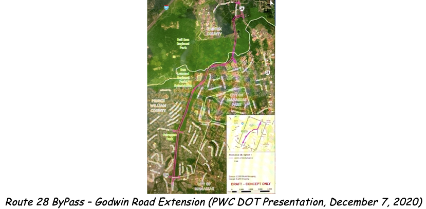
Fairfax County continues the widening of the portion of Route 28 north of the Fairfax County/Prince William County boundary to U.S. Route 29, to three lanes in each direction and making improvements to existing intersections – this project is currently scheduled for completion in 2023. Prince William County is widening Route 28 to a six-lane divided roadway between Linton Hall Road and Pennsylvania Avenue. The City of Manassas is widening Route 28 to six lanes between Pennsylvania Avenue and Godwin Drive through the Prince William County Parkway (Rte. 234)/Route 28 interchange. These specific projects collectively leave a section of Route 28 between Godwin Drive and the Bull Run as is - - this is the Route 28 section that is the focus of Prince William County’s Route 28 Bypass Project.
On September 8, 2020, the Prince William Board of County Supervisors voted to approve the PW Staff recommendation to adopt the Godwin Drive Extension alternative (Alternative 2B) for the Route 28 Bypass. The Board also approved, as a back-up plan should the Godwin Drive Extensions encounter significant obstacles that render it non-usable, the initiation of a Comprehensive Plan Amendment for widening Route 28
The threatened sites that, beginning in 2017, BRCWRT has been working in partnership with Northern Virginia Regional Park Authority (NOVA Parks) and Manassas National Battlefield Park (MNBP) to preserve and mitigate the Bypass impacts on include Bull Run Regional Park, the Blackburn’s Ford Battlefield and the 1st Manassas (Bull Run) Battlefield.
The current projected timeline for the Route 28 Bypass project is:
-
Design and Engineering
-
Right of Way & Utilities
-
Construction
2021 – 2023 2023 – 2025 2025 - 2027
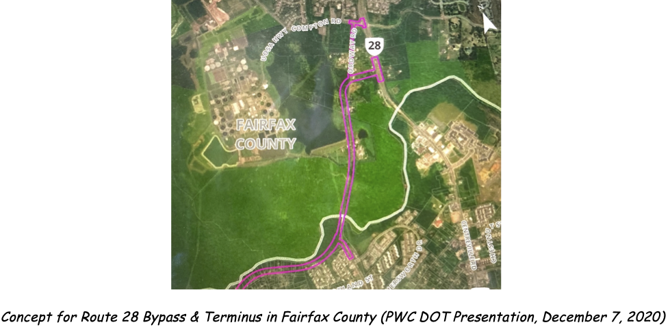
BRCWRT continues to monitor this project and, in collaboration with the NOVA Parks and MNBP, will continue engaging with the Prince William County Department of Transportation (PWC DOT) to ensure potentially threatened cultural and historic sites are protected. Known historic sites within the Bull Run Regional Park at the Ordway Road Crossing of Bull Run include the Mitchell’s Ford site and remnants of civil war earthworks constructed to guard the ford. Additional historic sites north of the Bull Run may be discovered as the ultimate route to, and location of, the Bypass intersection with Route 28 in Fairfax County is determined. PWC DOT plans to host information sessions on the Route 28 Bypass project and address topics specific to Prince William County in the near future.
Historic Conner House (City of Manassas Park)
The City of Manassas Park’s plan to redevelop Manassas Park’s City Center area in a four-phase project envisions replacing the current City Hall with a new multi-story structure that will include retail stores, a city square public plaza, an apartment complex and a nine-screen movie theater, along with the attendant public parking lots and a multi-story parking garage. Phase 4 of the City Center development concept includes two, six-story apartment complexes with a covered parking garage, one of which is to be built on the Historic Conner House site and would include removal, or repurposing, of the Conner House. The Conner House, located in the vicinity of 8220 Conner Drive, is directly threatened by the Center City Development Plan that was approved by the City of Manassas Park’s Governing Body on June 16, 2020
Subsequent outreach led to a connection with members of the Prince William County School Staff and School Board, who are interested in saving and preserving the Conner House. Discussions through July and August 2020 led to a concept for relocating the Conner House to a site on property, owned by Prince William Schools, and that is adjacent to the current (original) Conner House site. In discussions with School Board members the proposed concept was positively received; however, a formal presentation to, and consideration by, the School Board is on hold pending concept consideration and approval by the PW Board of County Supervisors.
BRCWRT representatives continue, in partnership with the PW Historical Commission, its initiative to meet with PW County Supervisors and discuss the threat to the historic Conner House and the concept for relocating, preserving and interpreting the Conner House. County Supervisors met with to date have been supportive of the concept, but as in all such matters funds to implement the concept promise to be a significant issue. Time is critical as the developer is currently developing the requisite rezoning application(s). Consideration of the zoning application(s), including public hearings, and site planning are anticipated in the Spring of this year, with ground breaking likely in the Summer.
Ox Hill Battlefield Park (Ox Hill and Chantilly Monuments)
Installation of the soldiers’ monuments (Ox Hill and Chantilly) at Ox Hill Battlefield Park, and the previously announced dedication ceremony scheduled for September 9, 2017 were “postponed indefinitely” by Fairfax County Park Authority (FCPA) officials on July 11, 2017. More than three years of BRCWRT efforts to work collaboratively with the FCPA and Park Authority Board to install these monuments, key elements of the interpretive concept within the approved Ox Hill Battlefield Park Master Plan, have been unsuccessful and extremely frustrating.
During its January 23, 2019 Park Authority Board meeting, the Board voted to approve the recommendation of the Executive Director:
The Park Authority Executive Director recommends to not install the monuments in their current form; and recommends that the Park Authority Board establish a subcommittee to work on the disposition of the monuments, as discussed by the Committee of the Whole on January 9, 2019.
No subsequent action has taken by FCPA or the Park Authority Board since this vote. During the two- plus year period preceding the Park Authority Board’s January 23, 2019 vote the FCPA and the Board publicly stated their intent to work wiBRCWRT to identify and resolve issues regarding the monuments but never followed through on this commitment, and consistently misled the BRCWRT with respect to their intentions and actions. Additionally, the FCPA and the Board have neither established nor convened the subcommittee specified in the Board’s January 23, 2019 vote, and have not responded to multiple BRCWRT inquiries and offers of assistance.
In January 2020 BRCRT requested, via letters to each County Supervisor and the Chairman, that the Fairfax County Board of Supervisors direct the Park Authority Board to: 1) clearly identify the specific wording and/or inscriptions on the monuments that it deems inappropriate; 2) fully establish and convene the subcommittee to resolve the specific wording and/or inscriptions deemed inappropriate; and 3) complete the disposition (installation) of the monuments in accordance with the Ox Hill Battlefield Park General Management Plan and Conceptual Development Plan that was approved in January 2005.
BRCWRT members Blake Myers & Greg Wilson met with Springfield Supervisor Pat Herrity’s staff members on March 11, 2020 to discuss BRCWRT’s January 2020 letter/request for support from the Fairfax County Board of Supervisors and the history of the Ox Hill Battlefield Park and the monuments. Following this discussion we provided staff a 3-ring binder with an index and nineteen (19) chronologically sequenced documents covering subjects including the histories of the Park, of the soldiers’ monuments and of BRCWRT’s interactions with FCPA and the Park Authority Board. Planned follow up actions, in collaboration with Supervisor Herrity’s office, to engage in discussions with the other District Supervisors and the FCPA were subsequently deferred due to coronavirus health and safety restrictions and Board of Supervisor higher priorities associated with the 2021 budget and the coronavirus pandemic.
Farr’s Fort (Civil War Redoubt on GMU Fairfax Campus)
Local
historians have long known of the
significance of the area surrounding the
Ox Road (Route 123)/Braddock Road (Route
620) intersection (a.k.a. as Farr’s Cross
Roads). Several studies, including the
Fairfax County Civil War Sites Inventory
(2002), have documented the existence of
Civil War-era redoubts, earthworks and
camps in the area surrounding this
intersection. Of particular interest is a
redoubt and set of earthworks constructed
by Colonel Robert Rodes’ 5th Alabama
(Ewell’s Brigade) in July 1861, prior to
Battle of 1st Manassas (Bull Run), located
on George Mason University’s (GMU),
Fairfax Campus. This historic site is a
forested knoll in the northeast quadrant
of the Ox Road/Braddock Road intersection,
and includes Farr’s Crossroads, Civil War
earthwork fortifications constructed in
1861 and used by both Confederate and
Federal forces throughout the war, and is
adjacent to the historic Fairfax Court
House - Fairfax Station corduroy road
whose remnants were discovered during road
construction along Rt. 123/Ox Road in 2015
and 2016.
The site is documented in the Fairfax
County Civil War Sites Inventory completed
by John Milner Associates, Inc. for the
Fairfax County Park Authority (FCPA) in
2002 and is included (Site 44FX185) in
both Fairfax County’s and Virginia’s
historic site databases. Archaeologist
Brian Corle, while a student at George
Mason University (GMU), completed the Archeological
Assessment of Site 44FX185, The Earthwork
at Farrs Crossroads Fairfax County,
Virginia (DHR File Number 2008-1541) in November
2008.
During August and September 2020 BRCWRT developed, in collaboration with GMU the Farr’s Fort Interim Preservation and Interpretation Project Plan (Revised), published on September 26, 2020. The Project Plan was approved by GMU’s Vice President of Facilities and forwarded to GMU’s Director of Facilities Management to develop a plan to execute the work described in the plan.
On October 6-8, 2020 GMU’s Grounds Maintenance Department cleared the redoubt of undergrowth, vegetation and brush, and treated the redoubt with herbicide. They then cleared, added gravel where necessary to level the ground, and covered with wood chips the redoubt access and interpretive trails.
Beginning on September 30, 2020BRCWERT members Blake Myers, Jim Lewis and Brian McEnany began meeting and working with GMU’s Environmental Graphic Designer on the design, development and production of the two historical markers as called for in the Project Plan (Revised) - a two-sided Vertical Historical Marker at the access trail entrance and a Horizontal Interpretive Marker at the redoubt. Design and content development for both markers were completed in November 2020. Fabrication of marker stands and panels is on-going, with the markers installation anticipated in the Spring of 2021.
BRCWRT continues its support of the initiative by the Prince William County Planning Office, the Prince William County Historical Commission, the Prince William County Historic Preservation Division and the Prince William County Historic Preservation Foundation to preserve and interpret Signal (Willcoxon) Hill. The Prince William County Board of Supervisors received proffer funds from Verizon as part of the use agreement for Signal Hill Park property used for the cellular communications tower that was installed in 2017. The intent is to transfer these funds to the Prince William County Historic Preservation Foundation to be used, in conjunction with Virginia preservation grant funding, for conducting a preservation study of the Signal (Willcoxon) Hill site.
The initial draft preservation concept, depicted below, includes a Signal Hill interpretive trail with multiple historical/interpretive markers, and a trail linking Signal Hill to the nearby Signal Corps
Monument wayside located along Signal View Drive. One challenge in preserving Signal Hill is that the northern section of Signal Hill is on privately owned property
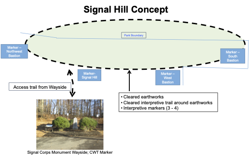
During their December 10, 2019 Prince William Board of County Supervisors meeting, the Board approved the transfer of the $10,000.00 proffer for the purposes of historic preservation and/or enhancements to Signal Hill to the PWC Historic Preservation Foundation. The Board also approved the Historic Preservation Foundation’s Annual Work Plan for 2020, which included a Signal Hill Cultural Resource Identification Study. This study is described in the Annual Work Plan as “The completion of a cultural resource study to identify cultural resources and interpretive themes for the Civil War era site. The project is to be completed in conjunction with the Prince William County Planning Office and the City of Manassas Park, Parks and Recreation Department.” As of January 2021, the proffer funds have not been transferred to the PWC Historic Preservation Foundation.
Manassas
National Battlefield Park (MNBP)
Preservation Projects
A. Transform 66
Outside the Beltway
As part of the
I-66 transformation/improvement project,
Dynamic Tolling Express Lanes are being
extended from the Capital Beltway to
Gainesville (http://outside.transform66.org/).
Threats to
MNBP include negative impacts (primarily
lighting and traffic noise) on the visitor
experience at historic sites located
adjacent to and along I-66 and Vandor
Lane, and the viewsheds from historic
sites adjacent to and near Vandor Lane.
Since 2017, BRCWRT has been involved as a consulting party (National Environmental Protection Act [NEPA], Section 106) working with and in support of MNBP to mitigate the Transform I66 project’s impacts on MNBP and the visitor experience to historic sites within MNBP. Through 2020 consulting parties have worked with VDOT and FAM Construction, LLC in reviewing roadway and Elevated Access Ramp design plans and negotiating revisions to those plans to eliminate and/or mitigate identified negative impacts on MNBP.
On December 15, 2020, VDOT/EMP/FAM notified consulting parties that FAM had procured MSE sample panels (drystack finish) and had applied staining in accordance with the color palette discussed in the last consulting party meeting (March 4, 2020). Three MSE sample panels with drystack finish and staining under consideration were placed on display at MNBP (Vandor Lane) for review by MNBP and other consulting parties, with comments due no later than January 15, 2021. MNBP was granted an extension for comment submittal due to caronavirus pandemic impacts and the temporary absence of MNBP key personnel. A final design decision on the MSE panels is the final piece in completing the Section 106 process for the Transform I66 project.
During a planned MNBP utility excavation in October 2014, the archeologist monitoring the work recovered bone fragments from the project site, suggesting the presence of human remains consistent with the use of the site as a field hospital, resulting in the recommendation for further archeological testing to confirm the interpretation and to determine the relationship among the archeological feature, artifacts, and human remains. In October 2015, National Park Service (NPS) archeologists and contract archeologists conducted further testing at the site and discovered two nearly intact sets of skeletal remains mingled with amputated limbs, and made the decision to conduct a program of data recovery to excavate the remains which were then transported to the NPS Museum Resource Center.
In April 2016, the NPS transferred the two sets of recovered skeletal remains to the National Museum of Natural History (NMNH) for forensic analysis, resulting in findings that the remains were associated with Union casualties from the Second Battle of Manassas. The skeletal remains were determined to be Union soldiers from the New England area, and likely from upstate NY. These remains were transferred from NPS to the U.S. Army on June 19, 2018, and were subsequently interred as ‘unknowns’ at Arlington National Cemetery on September 6, 2018 as part of the dedication ceremony for the new Arlington Millennium Section.
Disposition and potential historical interpretation of the limb pit and its artifacts remain under discussion between the NPs and Headquarters, Department of the Army, and are to-be-determined.
C. Gainesville Crossing (Across Pageland Lane from MNBP HQ)
This property, an approximately 200-acre tract along Pageland Lane opposite Stuart’s Hill & MNBP HQ & Visitor Center, is located on the south side of U.S. Route 29 (Lee Highway) between its intersections with Heathcote Blvd/ I-66 Exit 43B off ramp and Pageland Lane. Threatened sites include historic sites associated with the Battle of 2nd Manassas (Bull Run), the viewshed from Brawner Farm and the Dunklin monument (Timothy Dunklin, 4th TX Inf, killed at the Battle of 2nd Manassas [Bull Run])
On December
10, 2019 the Prince William Board of
County Supervisors voted to approve
Rezoning Request #REZ2018-00008,
Gainesville Crossing, which will include a
data center complex, an electrical
substation and twelve acres of commercial
storage and office space. The Gainesville
Crossing developer has agreed to donate
the parcel of land (Land Bay D) adjacent
to Pageland adn MNBP to the American
Battlefield Trust (ABT) and to donate
$25,000 to ABT for land parcel
improvements. ABT’s plan is to donate the
land parcel to MNBP.
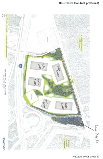
Preservation plans include a Historical Interpretive Marker covering artillery action during early phases of the Battle of 2nd Manassas (Bull Run) in the donated parcel adjacent to the intersection of Route 29 and Pageland Lane, and restoration of the Dunklin monument.
Thank you for your interest in, and support of, BRCWRT’s historic preservation actions and activities. Stay strong, stay safe and stay healthy in 2021!
Blake Myers
BRCWRT Preservation Chair